This piece will be updated throughout the week as more questions come in. If you have a question about redistricting (or are a journalist writing a piece) please email demography@unc.edu and we’ll do our best to answer your question.
We have been receiving a lot of questions concerning redistricting and the upcoming release of the redrawn maps in North Carolina.
We’ve talked about redistricting a lot, including what it is, why it’s complicated, and what the ideal district sizes are.
Here are some answers to some other common questions we’ve received:
The data used in redistricting are the 2020 Census State Redistricting Data (also referred to as Public Law 94-171 or PL 94-171 data). This data is released for very small geographic areas—down to a census geography known as a “tabulation block.” These small geographies allow lawmakers to better draw districts with equal populations.
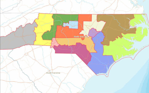
North Carolina is one of at least three states where Republican-led legislatures aren’t using racial or party data to draw state lines. (The others are Texas and Ohio.)
FiveThirtyEight has a good recap of what’s happened in North Carolina up through October 27th, when the North Carolina Senate Redistricting and Elections committee released its eighth congressional map, CST-10. The House Redistricting Committee has release one map.
WFAE’s redistricting overview has a great roundup of how redistricting works in North Carolina. The News and Observer’s guide details why lawsuits are likely, and has a slew of other deep-dives on redistricting in the state.
The Center for Urban Research at The Graduate Center of the City University of New York worked in partnership with the NC Counts Coalition to create the Redistricting & You: North Carolina online map. This tool helps individuals compare and analyze proposed district maps in North Carolina.
Maps must be made before December 6, because that’s the day when people can begin filing for congressional races. It’s likely they will be released in early November, according to the AP.
Need help understanding population change and its impacts on your community or business? Carolina Demography offers demographic research tailored to your needs.
Contact us today for a free initial consultation.
Contact UsCategories: Elections & Voting

The Center for Women’s Health Research (CWHR) at the University of North Carolina School of Medicine released the 12th edition of our North Carolina Women’s Health Report Card on May 9, 2022. This document is a progress report on the…
Dr. Krista Perreira is a health economist who studies disparities in health, education, and economic well-being. In collaboration with the Urban Institute, she recently co-led a study funded by the Kate B. Reynolds Foundation to study barriers to access to…

Our material helped the NC Local News Lab Fund better understand and then prioritize their funding to better serve existing and future grant recipients in North Carolina. The North Carolina Local News Lab Fund was established in 2017 to strengthen…
Your support is critical to our mission of measuring, understanding, and predicting population change and its impact. Donate to Carolina Demography today.